
Two Port Royal lots can look similar on a map yet sell millions apart. If you are buying or selling land here, small details like frontage, shape, and waterway type can swing value and build cost in a big way. This guide breaks down the geometry and shoreline factors that drive price, plus the rules that affect what you can build and where. You will leave with a clear checklist to make a confident decision. Let’s dive in.
Why geometry shapes price in Port Royal
Port Royal is one of Naples’ most exclusive coastal enclaves with limited inventory and headline sales at the very top of the market. Recent reporting highlights multi‑parcel and high‑eight‑figure trades, and scarcity magnifies the premium for unique lots with wide frontage or prime shoreline. Mansion Global’s coverage of Naples’ super‑luxury surge helps explain why uniqueness gets rewarded here.
Regulatory shifts also matter. Collier County adopted updated FEMA flood maps in 2024, which influence required elevations, permitting, and insurance. Those changes flow directly into land pricing and build feasibility. You can review the county’s guidance on floodplain management and DFIRMs.
Lot geometry that moves value
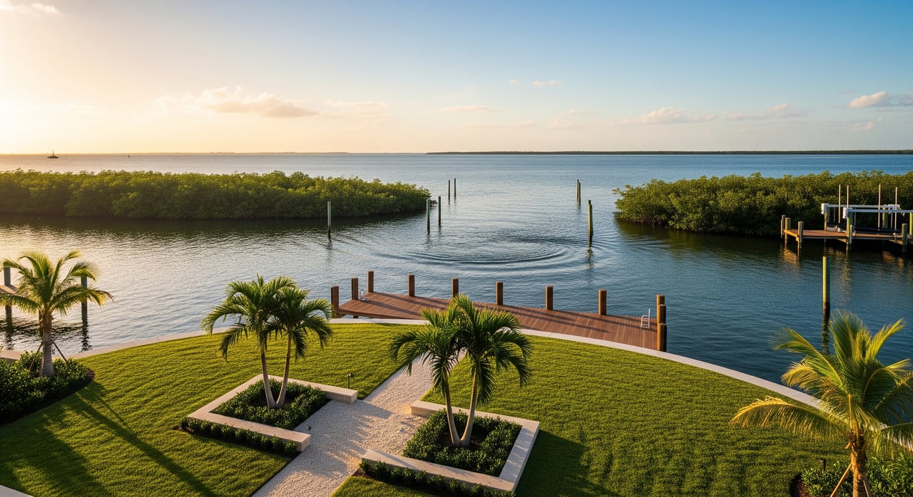
Waterfront frontage
Water frontage is a primary driver of price. More frontage usually means broader views, enhanced privacy, and better dock options. The market often shows diminishing returns per foot at very large widths, yet in Port Royal even modest added frontage can command a meaningful premium because it is scarce.
Lot shape and points
Point or peninsula lots that are surrounded by water on multiple sides are especially prized. They offer panoramic view corridors, more usable shoreline, and an elevated sense of privacy. Appraisal literature ranks “view area” and direct access as key value inputs for waterfront property pricing. See the discussion of view premiums in this water view appraisal overview.
Depth and setbacks
Depth determines the size and orientation of your home, outdoor spaces, and pool while respecting setbacks. Narrow deep lots can constrain design, and shallow wide lots can limit yard privacy. Collier County’s Land Development Code defines how setbacks and dock measurements are applied on coastal lots. Review the county’s dock and shoreline measurement rules when assessing buildable area.
Elevation and grade
Higher natural elevation often reduces construction complexity and future insurance costs because it is easier to meet Base Flood Elevation requirements. The updated DFIRMs guide finished-floor elevations and design choices. Start with the county’s floodplain resources to understand implications for your lot.
Orientation and sun
In Port Royal, west and southwest orientations can amplify appeal due to sunsets and breezes. Orientation also affects pool comfort, privacy from neighboring homes, and glare inside the residence. Appraisers fold these factors into “view quality” and overall utility.
Shoreline usability
A soft sandy beach is highly desirable for barefoot access and recreation. A high‑quality seawall can be equally valuable for boaters who want easy dockage on deep water. The age and condition of any seawall or dock is a near‑term cost and negotiation point, and local rules govern what can be replaced or extended.
Waterway types and price signals
Gulf beachfront
Direct Gulf frontage along Gordon Drive is exceptionally scarce and typically sets the highest per‑acre and per‑foot prices in Port Royal. Buyers pay for uninterrupted views, private beach access, and sunsets. Recent Naples coverage underscores how beachfront trades anchor the very top of the market. See Mansion Global’s reporting on Naples’ super‑luxury market.
Deep‑water bayfront
Lots on Naples Bay or similarly deep, protected water appeal to yacht owners because they enable large‑vessel moorage and quick Gulf access through Gordon Pass. For many boaters, a true deep‑water dock can rival beachfront value. Gordon Pass is the primary inlet serving Naples and is maintained for navigation, as noted in this boating guide to Naples and Gordon Pass.
Canals and inner bays
Canal parcels often provide sheltered water and private docks but may have width or depth constraints that limit dock protrusion and vessel size. These realities typically price canals below open bayfront, with notable exceptions for unusually wide or well‑located canals. Dock size and placement are governed by the county’s dock facility rules.
Mangrove frontage
Mangrove shorelines offer natural privacy and ecological character, but trimming or removal is tightly regulated. Dock access or view corridors may require permits and mitigation, which introduces cost and time. For rules and exemptions, consult the Florida DEP’s mangrove FAQs.
Seawall shoreline
Engineered shorelines preserve yard space and simplify dockage, which many boaters prefer. Replacement or upgrades require engineering and permits, and condition is a key due diligence item that can affect offers.
Buildability and permitting checks
Flood maps and elevation
Collier County’s 2024 flood map updates set Base Flood Elevations that affect design and insurance. Request an elevation certificate early and confirm the target finished floor with your engineer. County guidance is available here: Floodplain Management.
Dock and seawall rules
Dock location, length, and side setbacks are controlled by waterway width and measurement points like bulkhead lines. These rules shape whether a lot supports a large yacht, a lift, or a modest dock. Start with the county’s dock facility standards and consult your marine engineer.
Mangrove trimming limits
The Florida Mangrove Trimming and Preservation Act sets thresholds for trimming and requires qualified professionals for many activities. Non‑permitted work can trigger enforcement and mitigation. Review DEP guidance: Mangrove program FAQs.
Coastal control lines
Lots partially or fully seaward of coastal control lines face stricter standards and additional permits, which can add cost and time. Read the local provisions on coastal construction control lines to understand what may apply.
How to price a Port Royal lot
- Define the waterway type and frontage. Note linear feet, shoreline condition, and view width.
- Confirm dockability. Identify depth at mean low water, channel width, and distance to Gordon Pass using local expertise and navigation resources like this Gordon Pass overview.
- Quantify buildable area. Map setbacks, bulkhead lines, and any conservation buffers with the county dock and shoreline standards in hand.
- Model elevation cost. Align design with the 2024 DFIRMs and obtain an elevation certificate using Collier’s floodplain guidance.
- Inspect existing infrastructure. Commission seawall and dock evaluations to budget for near‑term repairs.
- Apply a view and orientation lens. West and southwest exposures can add utility and appeal. Appraisal literature on view quality offers useful context, for example this overview of water view valuation.
Buyer and seller checklists
Buyer due diligence
- Verify permitted dock envelope and side setbacks under county rules.
- Confirm depth and clearance to the Gulf. Note route and distance to Gordon Pass.
- Obtain an elevation certificate and align design with current DFIRMs.
- Order seawall and dock inspections. Budget for repair or replacement if needed.
- Check for mangrove constraints and DEP permit requirements.
Seller preparation
- Gather elevation certificates, surveys, and any coastal or dock permits.
- Document seawall age, repairs, and engineering reports.
- Highlight linear frontage, view width, and distance to Gordon Pass.
- Clarify shoreline type and usability, including existing lifts or dock capacity.
- Outline known regulatory considerations to reduce buyer uncertainty.
What makes a trophy lot
- Point or peninsula geometry with panoramic water views
- Wide, usable frontage that supports grand architecture and outdoor living
- Deep, dockable water with quick access to Gordon Pass
- Higher natural elevation that eases compliance with current DFIRMs
- West or southwest orientation for sunsets and breezes
- Shoreline that is immediately usable, whether soft beach or a well‑engineered seawall with permitted dock
Ready to talk?
Every Port Royal parcel is unique, and the right strategy blends geometry, waterway type, and regulatory realities with current comparable sales. For a private, data‑driven conversation about your next move, connect with the Knox Brothers.
FAQs
How does lot frontage affect Port Royal land value?
- Frontage drives view width, privacy, and dock options, which increases price. Very large frontage often shows diminishing returns per foot, but scarcity in Port Royal still rewards above‑average widths.
Are Port Royal beachfront lots always the most expensive?
- Beachfront usually commands the highest per‑acre and per‑foot values, yet a deep‑water bayfront lot with quick Gulf access can approach or match beachfront pricing depending on buyer priorities and recent comps.
What changed with Collier County’s 2024 flood maps?
- Updated DFIRMs set Base Flood Elevations that affect design, permitting, and insurance. Expect elevation certificates to be part of due diligence and pricing.
What limits dock size on Port Royal canals and bays?
- County rules set side setbacks and cap dock protrusion based on channel width and measurement points like bulkhead lines, which can limit lift size and slip length.
How do mangroves impact buildability and price in Port Royal?
- Mangroves provide privacy and habitat but trimming or removal is regulated. Where they block access or views, permits and mitigation may be required, which adds time and cost that buyers often price in.